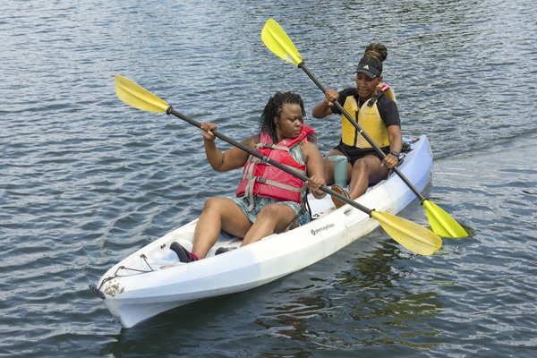
Texas has nearly 4,000 named streams that flow a total of some 191,000 miles, including through our major urban areas. A great way to enjoy these waters is by kayak — light, paddle-powered boats that are easy to handle and can go almost anywhere. Kayaks are available to rent in cities across the state, on your own or as part of a tour. Here’s our guide to experiencing your favorite city from the water.
Austin
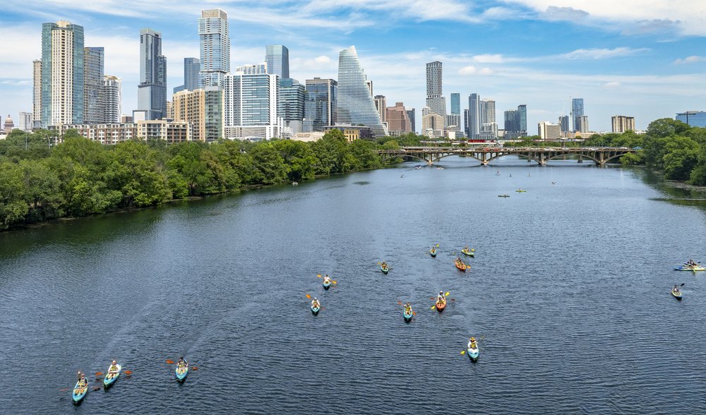
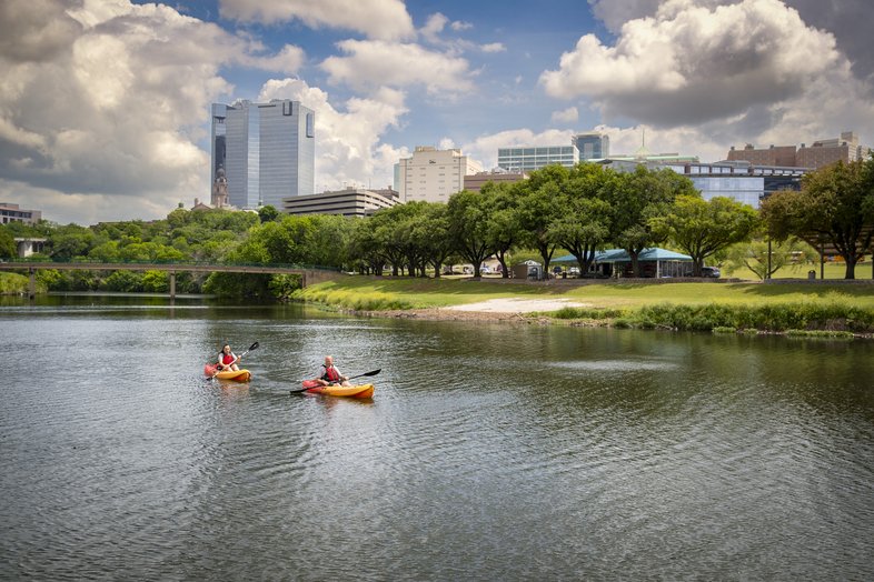
The Lady Bird Lake Paddling Trail stretches roughly 11 miles between Tom Miller and Longhorn dams. Paddlers with their own kayaks can access it at multiple launch points, including docks at Texas Rowing Center, Austin High and Festival Beach.
Bald cypress, cottonwood and other trees line the shore, and paddlers can see a variety of birds and other wildlife and fish for bass, sunfish and carp. Kayaks get you up close to millions of Mexican free-tailed bats leaving their roosts under the Congress Avenue Bridge at dusk from March to October. The downtown skyline provides an impressive photo backdrop from much of the lake.
Several outfitters provide rentals along the trail. Closest to Longhorn Dam in East Austin, Live Love Paddle on East Riverside Drive offers hourly rentals. The east end of the lake is less crowded and offers plenty of nature, says co-owner Casey Vick. There is also an island and a cove to explore, and views of downtown.
Austin Get Up and Go Kayaking offers clear boats, the better to see fish, turtles and other life in the water. Rentals, available by reservation, can start at several locations on the lake.
The Rowing Dock rents kayaks from the lake’s south shore at the western edge of Zilker Park, with Barton Creek a short paddle away. An upstream route passes a variety of flora and fauna, limestone bluffs, a natural spring and Red Bud Isle. Downtown is a short paddle downstream.
These outfitters also offer guided tours. Live Love Paddle’s include bat watching (which is about a 25-minute leisurely paddle each way), downtown and the east end of the lake. Get Up and Go Kayaking does bat and sunset tours (in lighted kayaks after dark), with flexible launch spot options. The Rowing Dock offers tours of the bats, Barton Springs and Red Bud Isle near Tom Miller Dam.
For those who want to paddle Lake Austin, the upper part of the lake offers less developed and trafficked waters. Peace Paddling rents kayaks from boat ramps at Commons Ford, Quinlan Park and Steiner Ranch Lake Club. The outfitter sets everything up and provides landmarks for inlets and coves that are worth exploring.
Dallas/Fort Worth

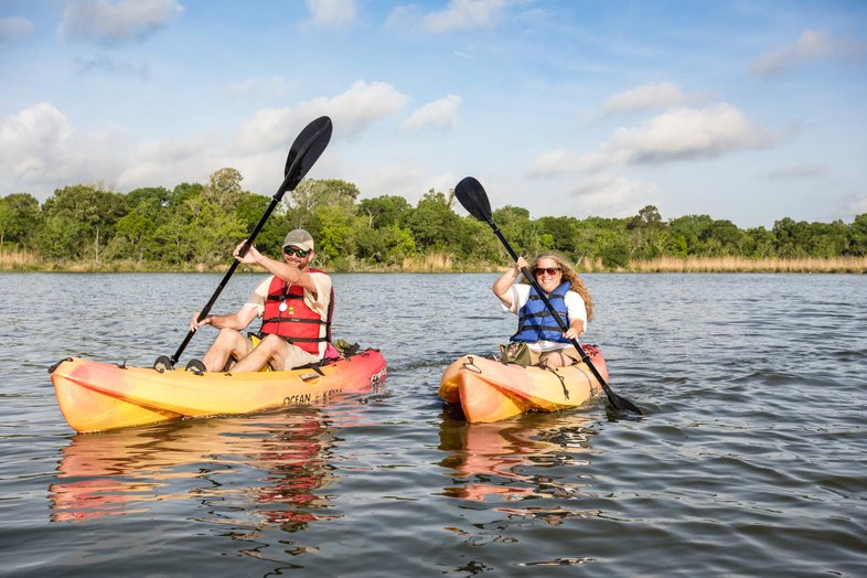
Trinity River in Fort Worth at the Panther Island Pavilion
Maegan Lanham
Trinity River in Fort Worth at the Panther Island Pavilion
Maegan Lanham
The Trinity River runs 710 miles, and the Trinity River National Water Trail covers 130 of them, from west of Fort Worth through the greater metro area and Dallas, with 21 official launch sites on the waterway’s three forks.
“One thing that makes the trail special is that it traverses multiple cities,” says Teresa Patterson, Trinity River National Water Trail manager. Wildlife along the waterway includes birds such as herons, egrets, ospreys, ducks, hawks and owls as well as deer, beavers, turtles and alligators. Cottonwood, pecan, black willow and oak trees grow along the shore as well as cattails, bulrushes and water willow.
Eight launch spots in the Fort Worth area offer paddles of varying lengths and landscapes. One is Fort Worth’s Panther Island, which offers a choice of the Clear, West and East forks. About a mile down the Clear Fork is a gravel bank where boaters can pull up and swim. The West Fork has a six-mile stretch through wooded and urban areas, with downtown skyline views on the way back. A guided full moon paddle goes out into the sunset and returns toward the full moon rising over the city lights.
The Fort Worth Nature Center and Refuge Paddling Trail is a loop of six to seven miles on the West Fork between the Eagle Mountain Lake dam and Lake Worth with two launch points, Big River Canoe and Greer Island. Paddlers may see Civilian Conservation Corps structures in the Greer Island area and can fish for sunfish, bass, crappie and catfish (the state health department advises not eating them). The Nature Center offers guided trips including a monthly full moon paddle. Check the online program calendar.
In between Fort Worth and Dallas are several significant portages, and distances between launches are
long, although more are in the works.
The Trinity’s Elm Fork runs from Lake Lewisville Environmental Learning Area nature preserve north of Dallas to join the West Fork near downtown, 27 miles total with eight launch sites and paddles two to 11 miles long.
Much of this route feels like a true wilderness, says Dale Harris of the Trinity Coalition. “I have seen just about every animal in North Texas on this fork — birds, turtles, wild hogs, rabbits, beaver, fish. On weekdays you may be the only one on the water.”
A 3.7-mile channelized stretch from the Trammell Crow Park boat ramp to Moore Park provides views of downtown Dallas and passes under the Margaret Hunt Hill Bridge, designed by architect Santiago Calatrava, and the circa-1912 Houston Street Viaduct, once the world’s longest concrete structure and listed on the National Register of Historic Places.
From there, it is 6.5 tree-lined miles to Loop 12, recommended only as an out-and-back route as the boat ramp there is damaged. Fish for sunfish, bass and catfish (but don't eat) and watch for beaver and a stand of Texas buckeyes. Paddling past Loop 12 is not recommended because of a dangerous lock and dam system downstream.
Houston

A guided tour with Pinky's Kayak Rental at Armand Bayou
Chase Fountain
A guided tour with Pinky's Kayak Rental at Armand Bayou
Chase Fountain
Armand Bayou Nature Center covers more than 3,500 acres in southeast Houston, many of them underwater. The center offers guided kayak tours on Saturday mornings that cover about three miles, are beginner friendly and are limited to 12 people. Guides discuss area birds and wildlife, like alligators, which paddlers often see.
The Armand Bayou Paddling Trail has launch points at Bay Area Park and Clear Lake Park on NASA Road 1 and offers natural scenery, wildlife and fishing, including for saltwater species where it connects with Clear Lake. Much of the area is part of the Armand Bayou Coastal Preserve, managed by the Texas Parks and Wildlife Department and one of four such preserves along the Texas coast. Paddlers may spot some of the more than 220 species of birds in the area, including ospreys, roseate spoonbills and pelicans.
Pinky’s Kayak Rentals offers three-hour rentals starting at Bay Area Park, from which paddlers can access five different areas: Big Island Slough, Spring Gully, Armand Bayou, Horsepen Bayou and Lake Mark Kramer (Mud Lake). The outfitter provides a map, directions and a quick lesson.
“I love to get people onto the bayou and then see them come out more often,” says Stacy Holcomb, one of the owners. “You’ll see alligators, birds, dragonflies, butterflies and turtles right in our backyard.”
Across town, the Buffalo Bayou Paddling Trail covers 26 miles from near Highway 6 at Interstate 10 west of Houston to Allen’s Landing Park downtown. Ten launches offer segments of less than one hour to up to four hours. The bayou is home to birds like herons and hawks as well as rabbits, turtles and an occasional alligator. Paddle under black willow, cottonwood, loblolly pine, oak and hickory trees, often with no urban structures in sight.
Buffalo Bayou Kayak provides downtown skyline and sunset tours, and three-hour paddles to watch the dusk emergence of bats from the Waugh Drive bridge.
“We put in at the original port of Houston, and head through the theater district past old 1880s to 1900s warehouses,” says David Urias, lead tour guide. “I’ve spent a lot of my adult life exploring downtown and even I didn’t know some of the things that can be seen on the bayou. You see these old landmarks and better appreciate the foundation of the city.”
“The bayou was the city’s original highway,” he adds. “It slows you down, you don’t have to worry about traffic. Being on the bayou helps put people in a better frame of mind.”
San Antonio
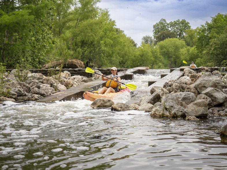

San Antonio's Mission Reach Paddling Trail
Maegan Lanham
San Antonio's Mission Reach Paddling Trail
Maegan Lanham
Mission Reach Paddling Trail covers eight miles of the San Antonio River south of downtown from Roosevelt to Espada parks, about a four-hour paddle one-way. Multiple launches are marked by tall blue buoys, and there are about 20 chutes or gently sloping concrete waterfalls.
Over 200 species of native plants grow along the banks, including some 20,000 trees planted as part of an ecosystem restoration project.
Michael Gramley, recreation superintendent for the San Antonio River Authority, says paddlers can glimpse parts of the missions that give the trail its name, as well as art installations and wildlife. “An avian study found some 40-odd species of birds living along the trail, including herons, egrets and other wading birds,”says Gramley. “There are turtles and quite a few fish, with catch-and-release fishing for bass, catfish and sunfish.”
For a short, shady paddle in the King William area, he suggests starting near the River Authority offices on Gunther Street and paddling about a mile to the first weir and then back.
“The whole trail is a hidden treasure, a green space just a few miles from downtown,” Gramley says. “I think people will be amazed by the sights they can see. I like the peacefulness and solitude of kayaking. Kayaks are
super-easy, and this river is beginner friendly.”
Texas River Company in Roosevelt Park provides hourly rentals by reservation every day from 8 a.m. to 5 p.m. and schedules and group events.