On a blistering July day in 1877, a troop of 10th cavalry buffalo soldiers abandoned a hunt for Comanche raiders and began a desperate quest for water to save their own lives.
They were lost in the dry sands west of present-day Tahoka, Texas, and long since had emptied their canteens. Staggering from thirst and heat exhaustion, several soldiers would die without reaching the life-saving waters of brackish Double Lakes.
Some years ago I visited a spot where the troopers spent an agonizing night after turning back. A windmill was pumping cool water into a steel trough for nearby cattle. Ironically, the thirsty troopers had no way of knowing that just beneath their feet lay the largest aquifer on the North American continent, the Ogallala.
Slow erosion of the Rocky Mountains through uncounted ages built the sands of the Ogallala. The water being used so rapidly today was accumulated over thousands of years by slow percolation from rivers, streams and a myriad of shallow natural playa lakes that shine like mirrors across the undulating plains after a rain. The aquifer underlies all or parts of 46 Panhandle counties and stretches northward into South Dakota. Since prehistoric times its clear, clean waters have risen to the surface in hidden springs long known only to Native Americans and to an astonishing variety of wildlife.
Now the Ogallala is an endangered aquifer. Specialists have estimated that on the Texas High Plains, half of the original groundwater already has been pumped out, mostly in just the last 50 years. Even under an ambitious long-range state conservation plan, half of what remains today may be gone by the year 2050. As bad as that figure looks, it may be overly optimistic, especially in heavy-use counties.
The Ogallala produces three-fifths of the groundwater used in Texas. About 90 percent goes for irrigated farmland, yielding much of the nation’s grain and cotton. The rest goes to municipal, industrial and livestock interests. Amarillo, for example, derives about 40 percent of its water needs from groundwater.
Adding to the already darkening clouds, in the Ogallala’s future are controversial proposals to export groundwater to distant urban areas. At the time of this writing, six landowners, most prominently T. Boone Pickens and a utility company subsidiary, have applied for permits to move water out of Roberts County at the rate of about 150,000 acre-feet per year. This would be comparable to present levels of use in heavily irrigated counties such as Carson, Dallam or Hartley.
Roberts is mostly native-grass rangeland not suited for cultivation. Pickens’ own Mesa Vista Ranch north of Pampa is typical of the rough, rolling terrain. For years conservationists have regarded his ranch as an excellent model of range management and wildlife enhancement. Opponents see his proposal to pump water from beneath the ground as a contradiction to his extensive conservation work on the surface. They fear this extra water withdrawal would cause rural communities to dry up for the benefit of the investors and distant urban areas.
Because Roberts County has little irrigation, drawdown of the aquifer beneath it has been minor. Many landowners have been offered as much as $350 per acre for water rights, probably $100 to $125 more than the sale value of the land itself. It has been said that water flows uphill toward money. Ranchers beset by years of low cattle prices see sale of water as a potential windfall. Many support it.
Groundwater in Texas is managed by landowners under the Rule of Capture, or by landowners and groundwater conservation districts working together. The Texas Supreme Court adopted the Rule of Capture in 1904, on the grounds that groundwater was “too secret, occult and concealed” for regulation. Under the Rule of Capture, which the Texas Supreme Court upheld in a 1999 decision, landowners can pump groundwater regardless of impacts to neighboring landowners. Groundwater conservation districts have been created in some parts of the state to manage groundwater through such means as well spacing and pumping rates. Today local groundwater conservation districts are the state’s preferred method for groundwater management.
The question of Panhandle water exportation remains tied up in litigation. However, precedents already exist. Amarillo and the Canadian River Authority have acquired rights to drill 40 wells on more than 40,000 acres in Roberts County. The City of Amarillo has bought 71,000 acres adjacent to Pickens’ ranch. Pickens and other landowners argue that if they are not allowed to pump water from beneath their land, others will siphon it off, anyway.
The controversy points up the fact that future water shortages are Texas’ number-one long-range problem, and they will not be confined to the High Plains. It is easy, though painful, to visualize a future when Texas irrigated farming will be only a memory, and towns and cities will send delegations to Austin to fight over depleted remnants of groundwater. Water engineers agree that most logical dam sites in the state have already been developed. They see little prospect for new lakes to provide significant additional surface water. Underground water will become more and more valuable as the supply becomes scarcer.
If we mess up, we mess up for a long time.
C.E. Williams, Panhandle Groundwater Conservation District Office
Texas uses more groundwater per day than any state except California. The Ogallala is one of Texas’ nine major aquifers, all of which are facing similar basic problems in varying degrees. Other large ones include the Gulf Coast Aquifer, underlying 54 counties, and the Edwards, underlying central West Texas. San Antonio is the largest city depending solely upon an aquifer, the Edwards, for its water supply.
Smaller aquifers include the Trinity in North Central Texas; the narrow Carrizo-Wilcox stretching snakelike from Northeast Texas all the way to the Rio Grande; the Seymour in scattered patches just east of the Ogallala; the Cenozoic Pecos Alluvium along the upper reaches of the Pecos River; and the Hueco-Mesilla Bolson at the El Paso tip of the state.
The Edwards has one fortunate characteristic the Ogallala does not. Its water table can sink to an alarming degree, then begin rising within days after rain falls in the porous hills along the Frio and Nueces watersheds. The Ogallala recharge rate is so slow as to be negligible. Where water levels in much of it have declined two feet a year, the annual natural recharge may be as little as one-tenth of an inch.
Like surface lakes, the Ogallala tends to be shallow around the edges and deeper in the middle. The Texas High Plains are on the southern extreme, where depletion shows its effects more than in, say, Nebraska, which has deeper saturated thickness. In some edge counties to the south and west, economics have forced many farmers to revert to conventional dryland operations.
As a practical matter, most farmers will not pump the water table dry to the underlying red bed. The cost of bringing water to the surface becomes prohibitive before that point. Pumps operate on gas or electricity. As fuel costs continue to rise, the market for farmers’ commodities remains chronically depressed. For example, cotton from the 2001 crop sold for around 30 cents a pound, just a third of its value two to three years ago.
A significant amount of land — an estimated 20 to 25 percent in some water-shy areas — has been placed in the federal Conservation Reserve Program, or CRP, under which it remains inactive except for cover crops planted to prevent wind erosion.
C.E. Williams, who heads the eight-county Panhandle Groundwater Conservation District office in White Deer, farmed in Carson County for 19 years. Because of the declining water table, parts of his homeplace reverted to dryland cropping long ago, moving from water-loving plants such as corn to dryland grain sorghums, wheat and sunflowers.
Farming communities suffer when the pumps go idle. Panhandle is a typical plains farming town, set in a deep-soil landscape flat enough to invite the plow. Williams says his hometown in the late 1970s had four farm implement dealerships. Now it has none. It had a strong rural bank. That closed five years ago. Three formerly independent grain elevators have consolidated into a single ownership.
Not all of the picture is negative. High costs have compelled farmers to seek increased efficiency. Though limited irrigation on the Texas plains began as early as 1911, it built momentum in the late 1940s and through the severe drought of the 1950s, peaking in the 1970s. Early flood irrigation allowed water to flow freely but wastefully down the furrows. As pumping costs and conservation awareness rose, curtailing waste became imperative. The first high-pressure sprinklers threw water high into the air, where much of it evaporated without reaching the ground. Since the 1980s the trend has been toward center pivot systems with low-hanging nozzles that expel water on or close to the ground. This reduces evaporation loss and can regulate the flow better.
Even more efficient are drip systems, which apply water directly to the crop, though these can cost $700 to $800 per acre.
As one farmer remarked, “Paying for a drip system is like buying your farm all over again.”
To help farmers apply just the right amount of water and no more, state and federal agencies have jointly instituted an information system using 12 High
Plains weather stations to provide daily climatological reports on temperatures, solar radiation and relative humidity. These factors bear on plants’ day-to-day water needs.
Leon New, Extension Service agricultural engineer in Amarillo, finds that the rate of decline in water levels has slowed over recent years as farmers have increased efficiency of use.
Nevertheless, “Each gallon of water taken is harder to get and more costly than the gallon before it,” says Jim Conkwright, general manager of the High Plains Underground Water Conservation District No. 1, headquartered in Lubbock near the southern edge of the Ogallala. There, an estimated half of the original water is gone.
“We continue to mine the aquifer,” Conkwright says.
“Mining” is a term used often by water specialists. In effect, it means viewing water as an expendable commodity like oil and gas. It also means that when the water is taken out, it is gone forever.
“If we mess up,” Williams says, “we mess up for a long time.”
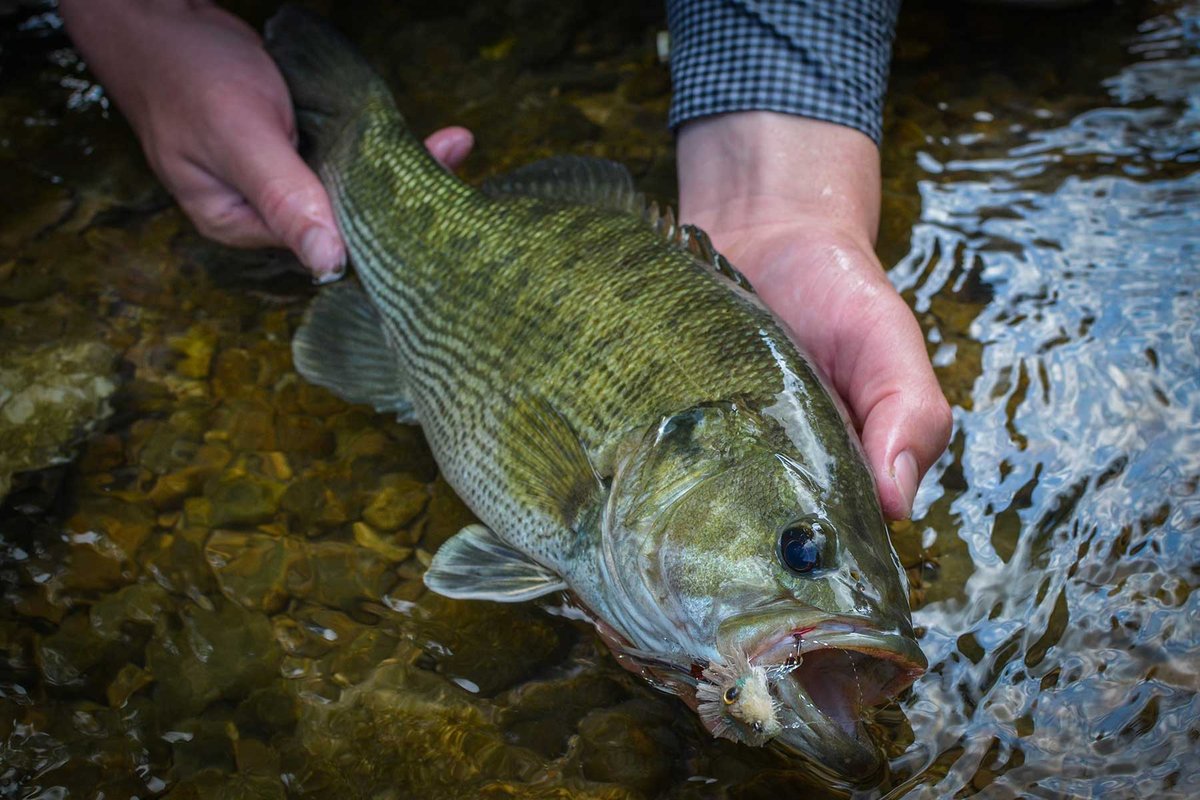
The more than 15,000 playa lakes scattered across the Texas plains are an important source of aquifer recharge. These natural depressions catch water from rainfall and snow. The playas are vital to wildlife, not only for water but for the many types of vegetation that grow up around their edges. Lubbock has 50 playa lakes within its city limits, to which thousands of Canada geese swarm each year. Up to 2 million ducks and uncountable numbers of geese depend upon the playas. Sandhill cranes are prominent winter residents, feeding around the lakes and from nearby grainfields. Game birds, shorebirds, waders, hawks and owls, as well as a variety of mammals find both shelter and sustenance in and from the playas. Pheasants and blue quail frequent the fields, picking up scattered grain.
Some ranchers, conscious of the financial as well as aesthetic value of wildlife, have provided such extra facilities as quail waterings. Even such a small thing as dragging a plow or grain drill across open rangeland encourages growth of weeds beneficial to bird life.
Ranching remains basic in the Panhandle economy. In general, it has suffered relatively little from the aquifer’s decline, except in localized areas where water tables have sunk below the depth of wells serving windmills. Livestock’s water needs are small in comparison to those of irrigated farming.
An exception is in the concentration of large numbers of cattle — and recently hogs — in commercial feedlot operations. So far, the Texas Cattle Feeders Association, headquartered in Amarillo, has noted no significant adverse impact from the aquifer’s situation. The most visible effect has been in grain supplies. Much irrigated corn acreage on the southern plains has been replaced by irrigated or dryland grain sorghums. Feedlots import increasing amounts of corn from the Midwest to supplement diminishing local supplies.
Dr. John Sweeten, resident director of the Texas A&M Agricultural Research and Extension Center in Amarillo, says ongoing biotechnology is emphasizing water-efficient plant traits that will require less irrigation.
Minimum tillage, leaving crop residues on the ground, helps conserve moisture from rain and snow and reduces the need for supplemental watering. Another method for increasing both ground and surface water is brush removal. Brush infests more than 50 million Texas acres, including much of the Panhandle. Texas A&M University studies indicate that the average mesquite tree uses about 300 gallons of water per year. In a model experiment on the small Rocky Creek watershed west of San Angelo, brush was removed from several ranches. A dormant stream soon returned to year-round flow.
Costly brush removal faces both economic and political problems, however. Urban taxpayers tend to regard it as a benefit only to landowners and question why they should help pay for it, though it would also increase cities’ water supplies.
Some of the earliest signs of man in this part of the continent have been found on the Texas plains. These first people, 10,000 or 12,000 years ago, almost certainly were drawn by the water and an abundance of game. Other people have come and gone through the ages.
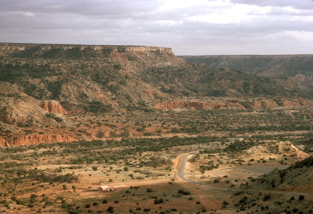
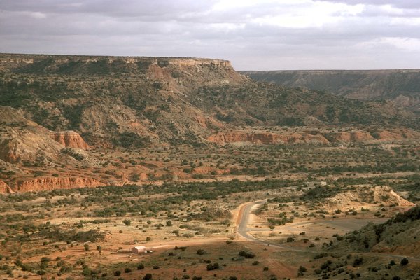
Recently, I stood on the rim of Tule Canyon, a spectacular chasm 700 feet deep at the jagged eastern edge of the High Plains escarpment, near Quitaque. It is an extension of the Palo Duro. Indians long ago carved handholds on the yellow-red canyon wall so they could climb the sheer rock face. Just a few hundred yards to the north, the U.S. Cavalry once fought a pitched battle with hostiles. Far below me, near the chasm’s boulder-strewn floor, clear Ogallala water bubbled out of the canyon wall to feed sparkling Tule Creek.
That visit gave me a look far back into the past. But it also afforded a disturbing vision of an all-too-likely future. The springs and the creek could dry up and die if the aquifer level continues to sink. Although this part of Tule Canyon is far from the highway and relatively unseen, we all instinctively would feel the loss. The creek, the canyon, the Ogallala itself, are part of our history, our heritage as a people.
If we exhaust it for today’s transient gains, what heritage do we leave for our children and grandchildren?